METHANE DOESN’T WAIT FOR YOUR INSPECTION SCHEDULE.
Leaks happen between surveys.
AIRMO closes the gap - with satellite coverage from orbit, backed by drone precision at ground level.
One platform, No blind spots
Full OGMP 2.0 compliance.

Satellites
Continuous, wide-area coverage
Aircraft
Fast surveys over large assets
Drones
Precise source-level detection
Airmo
for continuous methane emissions monitoring
AIRMO designs, builds, and operates methane monitoring tools - tailored to your site, your risk, and your reporting needs
Each system is purpose-built to deliver accurate, reliable, and cost-effective compliance
Working with


Detection from 1 g/h at drone scale. Our sensors find what OGI cameras and periodic walk-downs can’t — the leaks that fall between your inspection windows.

Every source measured in kg/h, source-attributed, uncertainty-bounded. OGMP 2.0 Gold Standard and EU Regulation 2024/1787 compliant. Reports ready to submit.

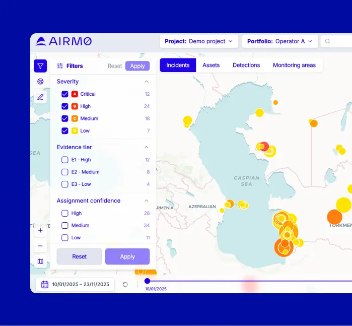
From a single compressor station to thousands of assets across multiple countries — one platform, one dashboard, one view. From public satellite feeds today, upgraded to AIRMO’s own active LiDAR satellite from Q1 2027.
How it works
Three steps.
No gaps.
01
We survey
Drone, aircraft, or satellite — matched to your asset size and geography. A coal mine in Germany, a refinery in Saudi Arabia, a pipeline in France. We deploy within weeks.
02
We quantify
Every detected leak is measured in kg/h, attributed to its source, and placed on a map. Full uncertainty quantification included. No estimates, no emission factors.
03
We report
Deliverables are OGMP 2.0 and EU Regulation 2024/1787 ready. Templates auto-populated. Audit trail included. From measurement to compliance in one step.
Built for the operators who need it most.
Our aircraft campaigns are planned in advance and capacity per region is limited.
Operators who book early secure their survey window and faster compliance delivery.
Europe
Austria
aut
Belgium
bel
Bulgaria
bgr
Croatia
hrv
Cyprus
cyp
Czech Republic
cze
Denmark
dnk
Estonia
est
Finland
fin
France
fra
Germany
deu
Greece
grc
Hungary
hun
Ireland
irl
Italy
ita
Latvia
lva
Lithuania
ltu
Luxembourg
lux
Netherlands
nld
Poland
pol
Portugal
prt
Romania
rou
Slovakia
svk
Slovenia
svn
Spain
esp
Sweden
swe
Middle East and North Africa
Algeria
dza
Egypt
egy
Libya
lby
Morocco
mar
Tunisia
tun
Iran
irn
Iraq
irq
Israel
isr
Jordan
jor
Kuwait
kwt
Lebanon
lbn
Oman
omn
Qatar
qat
Saudi Arabia
sau
Syria
syr
United Arab Emirates
are
Yemen
yem
Central Asia
Kazakhstan
kaz
Kyrgyzstan
kgz
Tajikistan
tjk
Turkmenistan
tkm
Uzbekistan
uzb
Middle East and North Africa
Algeria
dza
Egypt
egy
Libya
lby
Morocco
mar
Tunisia
tun
Iran
irn
Iraq
irq
Israel
isr
Jordan
jor
Kuwait
kwt
Lebanon
lbn
Oman
omn
Qatar
qat
Saudi Arabia
sau
Syria
syr
United Arab Emirates
are
Yemen
yem
*limited capacity per region
2027 Satellite Schedule Open
Operators who book early secure their survey window and faster compliance delivery.
Featured in
Backed by


Partners & institutional


FAQ
How do I reach OGMP 2.0 Gold Standard Level 5 for site-level methane reporting?
Reaching OGMP 2.0 Gold Standard / Level 5 means going beyond estimates to deliver robust, measurement-based methane reporting for specific assets. At this level, companies reconcile detailed bottom-up inventories (source-level data) with independent site-level measurements — the highest standard of transparency and accuracy under the OGMP framework.
What it requires
Source-level quantification (Level 4): replacing generic emission factors with measurement-based data.
Site-level measurements (Level 5): conducting full-facility surveys using advanced instruments tailored to the site, mostly from the air.
Reconciliation: aligning source-level and site-level results to resolve discrepancies.
Uncertainty analysis: quantifying confidence ranges of both measurement approaches.Implementation plan: bringing all operated assets to Level 5 within 3 years, and non-operated assets within 5 years.
Annual reporting: publishing reconciled data and methane reduction progress to UNEP.
How AIRMO supports you
To conduct Level 4 (source-level) measurements we deploy our proprietary sensors complemented with sniffers and OGI cameras where pinpointing component-level emissions matters most. The exact mix of tools depends on the facility type (e.g., storage sites, compressors, processing plants).
For Level 5 (site-level) measurements we use UAS-based TDLAS sensors or airborne push-broom spectrometers, selected according to facility type:
UAS-mounted systems for compact, high-density facilities (e.g., compressor stations, storage).
Spectrometers for wide-area, mostly upstream assets (e.g., production fields, gathering systems).
For reconciliation we provide proprietary AIRMO software built on OGMP 2.0 guidelines to reconcile source- and site-level data, quantify uncertainties, and generate standardized UNEP reporting templates ready for submission.
To support compliance & transparency, we use workflows aligned with OGMP 2.0 and the EU Methane Regulation, ensuring credibility, efficiency, and regulatory acceptance.
While site-level measurements are the core of Level 5, satellite data provides a powerful complement. AIRMO’s high-resolution satellite monitoring helps identify super-emitters, prioritize facilities for detailed surveys, and independently verify reductions at scale — making reporting not just compliant, but also future-proof.
Flight-planning best practices for UAV methane surveys
UAVs are a powerful tool for methane detection and quantification at facility scale, but flight planning must be adapted to the objective of the survey and the site characteristics. Broadly, UAV methane surveys follow two complementary approaches:
1. Detection flights (screening mode)
Objective: Identify whether methane is being emitted and locate likely sources.
Method: Fly transects above and around the facility to detect elevated methane concentrations in downwind plumes.
Best practices:
- Maintain multiple passes at varying altitudes to account for wind shifts and plume rise.Ensure downwind coverage so that plumes from all potential sources can be captured.
- Use meteorological sensors (wind speed, direction, temperature) onboard or nearby to interpret plume dispersion.
- Focus on maximizing coverage rather than precise quantification.
2. Quantification flights (flux mode)
Objective: Measure the total methane emission rate (e.g., kg/h) from the facility or from specific units.
Methods:
- Flux wall / virtual screen: Fly repeated transects forming a “wall” perpendicular to the prevailing wind direction, covering the full vertical and horizontal extent of the plume. Methane concentration and wind data are combined to calculate mass flux.
- Column integration with spectrometers: For large or diffuse sites, fly above the facility with a push-broom or imaging spectrometer. This provides a vertical methane column, which can be inverted using atmospheric models to quantify emissions.
Best practices:
- Align the flux wall orthogonal to the wind direction and extend beyond the plume edges.
- Fly at multiple heights to ensure complete plume capture, especially in variable wind conditions.Repeat flights to capture temporal variability (intermittent emissions, operational cycles).
- Use on-board or co-located meteorological measurements for accurate wind field characterization — a critical input for quantification.
- For spectrometer flights, ensure sufficient altitude to capture the full plume but maintain spatial resolution for facility-scale attribution.
How AIRMO applies these methods
For methane detection surveys we use UAS-mounted TDLAS sensors flown around compact, high-density facilities to quickly screen for leaks.
For methane emissions quantification surveys AIRMO use several methods:
- Flux walls for compressor stations, storage, and processing facilities.
- Spectrometer overflights for upstream production areas with wider plume footprints.
AIRMO also can do integration with reconciliation. Flight data to be normalized into standardized units (kg/h) and fed into our reconciliation software, which aligns them with source-level inventories per OGMP 2.0 guidance.
What instruments are needed to quantify methane plumes reliably?
Quantifying methane plumes requires instruments that can do more than just detect methane — they must measure concentrations precisely, integrate those with meteorological data, and convert them into robust emission rates (e.g., kg/h). The choice of instruments depends on facility type, survey scale, and whether the goal is detection, quantification, or reconciliation.
1. In-situ sensors (on UAVs or ground vehicles):
- TDLAS (Tunable Diode Laser Absorption Spectroscopy): High-sensitivity, fast-response sensor ideal for UAV surveys. Best for compact, high-density sites (compressor stations, storage).
- Sniffers / methane analyzers: Point sensors that provide ppm-level concentrations for component-level checks or ground validation.
- OGI (Optical Gas Imaging) cameras: Infrared cameras for visual leak detection; excellent for locating sources but not suitable for precise quantification.
2. Remote sensing instruments (airborne or satellite):
- Push-broom or imaging spectrometers: Capture column-integrated methane concentrations across a facility or region. Effective for wide, upstream areas and large plumes.
- LiDAR-based sensors: Map methane concentration in 3D, allowing plume reconstruction and quantification.
- Satellite sensors (e.g., AIRMO’s high-resolution constellation): Detect and quantify super-emitters, validate reductions, and prioritize sites for UAV follow-up.
3. Meteorological instruments (essential for flux calculations):
- 3D sonic anemometers / onboard wind sensors: Measure wind speed and direction at high frequency to calculate plume transport.
- Weather stations / balloons: Provide boundary layer and background data for flux modeling.
- GPS and barometric sensors: Ensure precise positioning and altitude control for UAV flux walls or transects.
4. Data fusion & quantification tools:
- Instruments alone are not enough — software is required to fuse methane concentration data with wind fields and flight paths.
- AIRMO’s reconciliation software converts raw sensor data into standardized emission rates (kg/h), applies uncertainty frameworks, and formats outputs for OGMP 2.0 reporting.
Best practice
- Use OGI + sniffers for detection and source confirmation.
- Use TDLAS or spectrometers for facility-level quantification.
- Always combine methane sensors with accurate wind measurements, since flux = concentration × wind speed × cross-sectional area.Integrate satellite data for independent verification and super-emitter detection.
How to generate source-level methane estimates acceptable to regulators
To be accepted by regulators and meet OGMP 2.0 requirements, source-level estimates must be measurement-informed, complete, transparent, and reconcilable with site-level data.
1. Define scope and materiality
Identify all material emission sources at each asset, including fugitives, pneumatics, tanks, compressors, flares, and intermittent events like blowdowns.
Conduct a materiality analysis to show which sources are included and justify any exclusions.
2. Use measurement-based methods for Level 4
Replace default emission factors with direct measurements wherever feasible.
Techniques include sniffers, FID, closed-path TDLAS, flow meters, or engineering calculations supported by measured data.
3. Ensure comparability (units, timing, operations)
Report emissions in standardized units such as kg CH₄/h or tons/year.
Align estimates to actual operating conditions: note which equipment was active, if flaring occurred, and account for maintenance or downtime.
4. Quantify uncertainty and detection limits
Provide uncertainty ranges for each source category.
Disclose detection thresholds and explain how measurement variability, environmental conditions, and representativeness were managed.
5. Prepare for reconciliation with site-level measurements
The total of all source-level emissions should be compared to site-level flux measurements.
Any discrepancies beyond uncertainty bounds must be investigated and explained.
6. Document methods transparently
Keep a clear record of instruments used, calibration, activity data, operating status, and any assumptions or models applied.
Documentation should allow regulators or auditors to trace and verify your estimates.
7. Report in standardized templates
Submit inventories annually in OGMP-approved templates, including both source-level estimates and reconciliation notes.
AIRMO’s approach:
- Measurement stack: OGI for rapid leak screening; FID and sniffers for component-level quantification; closed-path TDLAS for high-precision measurements.
- Normalization & QA: Convert all sources into standardized units, aligned with operating states, with quantified uncertainties.
- Reconciliation: Compare summed source-level estimates with site-level flux data from UAV or airborne surveys, adjusting emission factors where necessary.
- Reporting: Deliver fully documented inventories in UNEP/OGMP formats, ready for regulator review.
What are standard operating procedures for methane site assessments?
Methane site assessments must follow structured, repeatable procedures to ensure data are credible, comparable, and regulator-ready. SOPs cover planning, measurement, data handling, and reporting.
1. Pre-survey planning
Define objectives: LDAR compliance, OGMP 2.0 Level 4/5 reporting, regulatory inspection, or research.
Asset mapping: identify all potential emission sources (valves, tanks, compressors, flares, vents, intermittent events).
Select technologies: OGI for detection, FID/sniffers for point quantification, TDLAS (open/closed path) or spectrometers for plume and site-level quantification.
Flight or route planning: for UAV/airborne surveys, plan transects and flux walls aligned with prevailing wind.
Safety assessment: site access rules, equipment clearances, UAV flight permits, and personal protective equipment (PPE).
2. On-site procedures
Site briefing: confirm safety, operating conditions, and asset status (compressors on/off, flaring, maintenance).
Background measurements: measure upwind methane levels to establish baseline.
Source-level checks (Level 4):
Use OGI to screen for leaks.
Quantify sources with FID, sniffers, or closed-path TDLAS.
Document location, source type, and operating conditions.
Site-level quantification (Level 5):
Perform UAV/airborne surveys with open-path TDLAS or spectrometers.
Build flux walls downwind of the facility.
Collect concurrent wind and meteorological data (speed, direction, stability).
Repeat passes: capture temporal variability and intermittent emissions.
3. Data handling and QA/QC
Normalization: convert concentration data to emission rates (kg/h) using wind and plume geometry.
Reconciliation: compare total source-level emissions with site-level flux; explain discrepancies.
Uncertainty analysis: quantify detection thresholds, instrument precision, and representativeness.
Calibration logs: maintain instrument calibration and performance checks.
Data storage: secure archiving of raw and processed data for audit and regulator review.
4. Reporting
Standard units: report in kg CH₄/h or tons/year.
Documentation: include methods, detection thresholds, uncertainties, operating conditions, maps, and flight paths.
Templates: submit inventories in OGMP 2.0/UNEP formats, aligned with EU Methane Regulation requirements.
Transparency: include explanations for gaps, assumptions, or adjustments made during reconciliation.
AIRMO’s SOPs in practice
Pre-survey: flight planning with site meteorology, equipment list, and materiality check.
On-site: OGI and FID for leak detection/quantification, UAV TDLAS for plume mapping, airborne spectrometers for site-level quantification.
Post-survey: reconciliation in our proprietary software, producing regulator-ready reports.
Deliverables: UNEP OGMP templates, technical annexes, and a full audit trail.